Reporter leads unexplained so far
- RWI-SITREP-017-L1CFB Gagetown: heat detected for about three hours on 28 Oct, still warm the next morning — DND has not said what burned or why
Where / whenInside one open, road-ringed clearing in the east of the training area, 45.741–45.755 N, 66.238–66.272 W. GOES-19: first heat 15:46 UTC (12:46 ADT), peak 112 MW at 18:26, last detection 18:41 (15:41 ADT), all through gaps in 85 % cloud. VIIRS: 35 daytime pixels over about 1.3 × 2.7 km on five passes; two more pairs at night, 29 Oct 06:57 and 07:16 UTC (1–2 MW).
WhyDND says a fire is burning in the northeastern part of the training area, is being monitored and is no threat to the public; it suspended training there and banned drones, but gave no size, start time or cause. The satellites give the start, the peak and the spread, and show heat still on the ground about 12 hours after the last daytime detection. A late-October burn would fall outside the base's published spring burning programme (April–May); DND has not said either way. For context: eleven days earlier, four soldiers died in the CFB Wainwright range fire (RWI-HC-001); nothing in our data links the two.
Would settle itDND / 5th Canadian Division Support Base Gagetown: what was burning in that clearing — range firing, an impact area, a prescribed burn — when was it reported, and is it out? The next clear Sentinel-2 or Landsat pass will show the scar against the clear image of 27 Oct (G1).
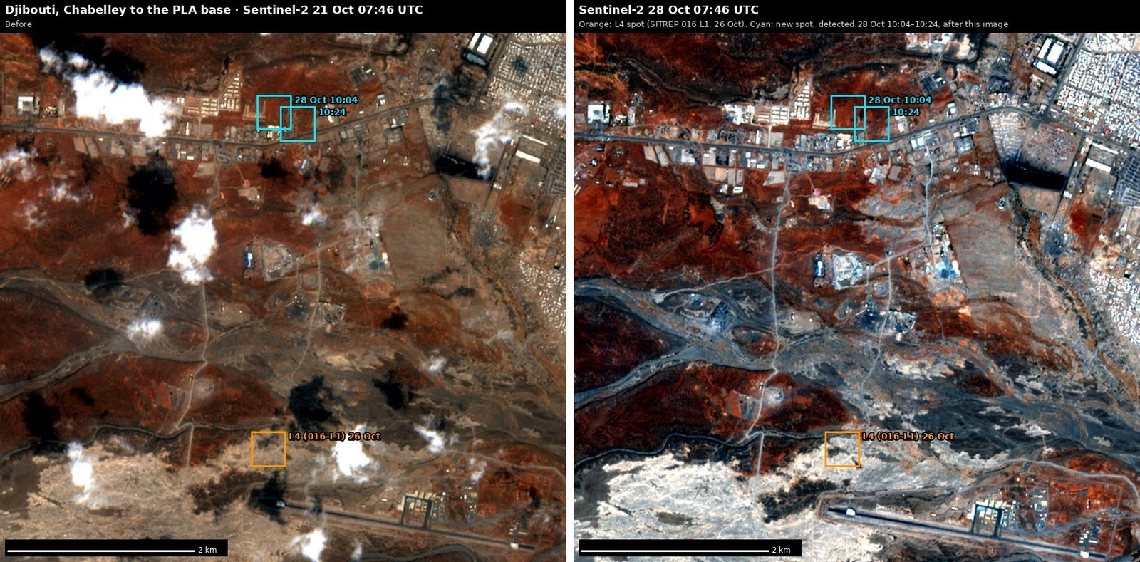
- RWI-SITREP-017-L2Djibouti: a first-time hot spot beside the main road between Chabelley and the PLA base
Where / when11.556–11.557 N, 43.050–43.052 E; 28 Oct 10:04 (S-NPP, 1.0 MW) and 10:24 (NOAA-20, 5.0 MW), daytime. About 3.6 km north of SITREP 016's lead at Chabelley and 2.8 km south of the PLA base box.
WhyNo detection within 1 km in 180 days of data. It fell outside the new Djibouti site boxes, so the alert filed it under the wide Djibouti box as routine. The pixels sit at the edge of a built-up strip north of the road (D1). A small daytime fire; the data cannot say what burned.
Would settle itThe next clear Sentinel-2 pass (the 28 Oct 07:46 image was taken two hours before the detections). Anyone on the ground on that stretch of road.
- RWI-SITREP-017-L3Western Libya: a night fire on the Zawiya coast, 7 km east of the refinery
Where / when32.793–32.795 N, 12.770–12.774 E, on the coastal dune strip between the beach and farmland; 27 Oct 23:56 (NOAA-21, 3.4 MW), 28 Oct 00:35 (S-NPP, 2.5 and 1.3 MW), 00:52 (NOAA-20, 1.7 MW).
WhyNot the refinery flare, which is 7 km west and burns every night; nothing at this spot in the 21–27 Oct pull. Three passes in an hour. They fall in SITREP 016's window but the FIRMS watch first recorded them at 20:21 on 28 Oct; its 05:21 and 05:49 runs did not.
Would settle itLocal reporting from Zawiya or Janzur for the night of 27–28 Oct. A clear Sentinel-2 pass: 28 Oct 10:01 was half cloud over the spot (Z1).
- RWI-SITREP-017-L4Djibouti: the recurring burn spot north of the Chabelley runway (carried from SITREP 016, L1)
Where / when0.5–0.9 km north of the western end of the Chabelley Airfield runway; burned 4 May, 22 Jun, 6 Jul and 26 Oct 2026.
WhyStill unexplained. The clear Sentinel-2 pass of 28 Oct 07:46 shows no obvious new dark patch at the 26 Oct detection (D1), but a 375 m pixel leaves room for a scar just outside the square. No new heat there in this window.
Would settle itCJTF-HOA / Camp Lemonnier public affairs: is there a waste-burning, disposal or training-fire site at or beside Chabelley, and who runs it?
- RWI-SITREP-017-L5Carried forward, unchanged: leads from SITREPs 008–015 with no status recorded (SITREP 016 did not carry them)
Where / when015-L1 Polish Air Force Gulfstream 0001 at Rzeszów (27 Oct); 014-L1 the Arava fire (27 Oct); 013-L1/L2 Wainwright (no RCAF search aircraft seen; Top Aces Alpha Jets 20–26 Oct); 012 Turkish A400Ms at Al-Watiya (2–3 Sep), SPAR75 at Chièvres (26 Oct), night fires west of Zawiya and south of Sabratha; 009/008 Yevpatoria night detections (24–25 Oct), the Khiam fire (25 Oct), the Sevastopol outage (25 Oct).
WhyNothing in this window settles any of them; each stays open until reporting or imagery does.
Would settle itAs in the original reports.
Summary
Satellites saw a fire at CFB Gagetown for about three hours on 28 Oct: GOES-19 detected heat from 12:46 to 15:41 ADT, peaking at 112 MW, and VIIRS put 35 fire pixels over 1.3 × 2.7 km inside one open clearing in the east of the training area; low heat remained the next morning. DND confirms the fire but not its size or cause. No obvious scar at the Chabelley spot in Djibouti on a clear 28 Oct pass, and a new spot by the road nearby; a night fire on the Zawiya coast. The new cloud mask went live.
Window 28 Oct 2026 00:30 MDT (06:30 UTC) → 29 Oct 2026 06:00 MDT (12:00 UTC)