Watches /
RWI-W-CENTRALCOAST
Central Coast Watch
Vandenberg, Point Mugu and the Navy's offshore range
RWI-W-CENTRALCOAST-2026-10-30flights 2026-10-29
Nothing out of pattern.
no flights kept · 0 heat (0 on sites)
Full report
Vandenberg, Point Mugu and the Navy's offshore range. Daily open-source look; flights for 2026-10-29 (UTC), heat for 2026-10-29–2026-10-30, newest satellite passes. LLM-generated and automated.
Notable
- Nothing out of pattern.
Flights
The adsb.lol archive for 2026-10-29 is not published yet; the next run fills it in.
Heat
0 detections in the watch box (FIRMS area API (agent Gazda)); 0 inside a site box. Launches from Vandenberg are short events; heat from a launch is caught only if a satellite passes within minutes.
Imagery
| Site | Newest clear Sentinel-2 pass (≤12 days) | |
|---|---|---|
| Vandenberg SFB — SLC-4 (SpaceX) | 2026-10-27 18:54 UTC, 100% clear | no new pass |
| Vandenberg SFB — SLC-6 | 2026-10-27 18:54 UTC, 99% clear | no new pass |
| Vandenberg SFB — north base test silos | 2026-10-27 18:54 UTC, 100% clear | no new pass |
| NBVC Point Mugu | 2026-10-27 18:55 UTC, 78% clear | no new pass |
| San Nicolas Island (Navy range) | 2026-10-24 18:45 UTC, 100% clear | no new pass |
RWI-W-CENTRALCOAST-2026-10-29flights 2026-10-28
- Unidentified aircraft a04eee (civil) within 25 km of San Nicolas Island 15:33–23:56 UTC.
- N118PA (SF34, civil) within 25 km of San Nicolas Island 14:22–23:26 UTC.
22 US military · 18 other low · 0 heat (0 on sites)
Full report
Vandenberg, Point Mugu and the Navy's offshore range. Daily open-source look; flights for 2026-10-28 (UTC), heat for 2026-10-28–2026-10-29, newest satellite passes. LLM-generated and automated.
Notable
- Unidentified aircraft a04eee (civil) within 25 km of San Nicolas Island 15:33–23:56 UTC.
- N118PA (SF34, civil) within 25 km of San Nicolas Island 14:22–23:26 UTC.
Flights
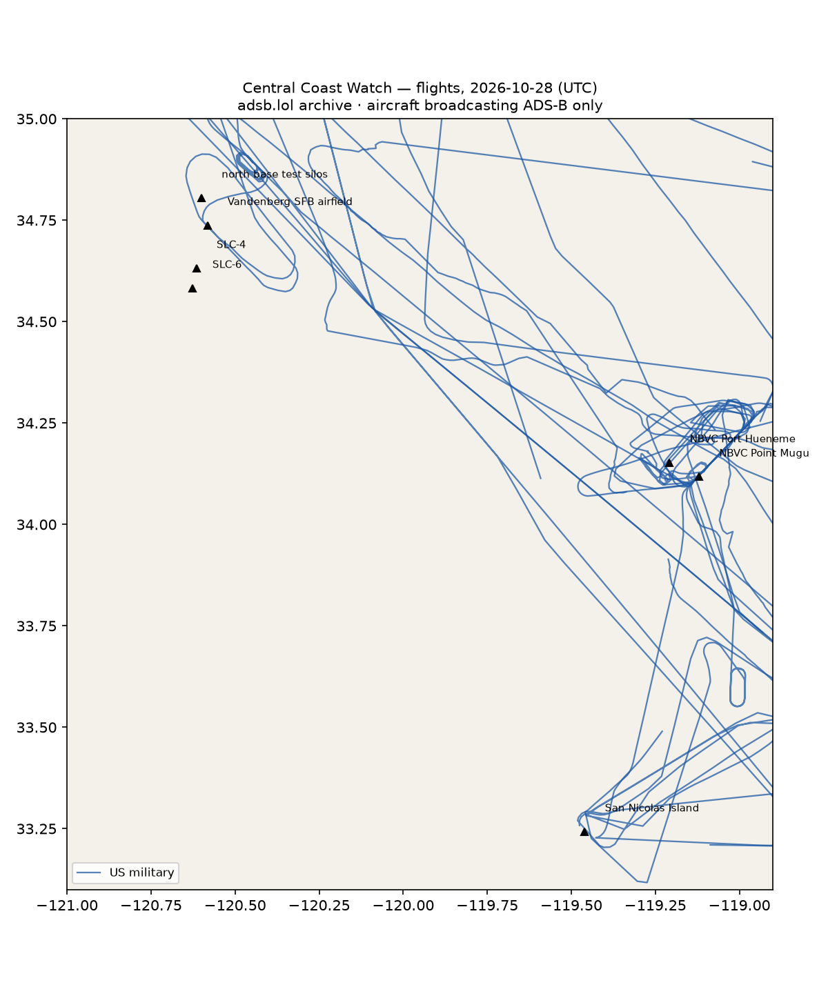
40 aircraft kept: 22 US military, 0 foreign military, 0 state/VIP, 18 other (on the ground at a site, or near a range).
Near San Nicolas Island (within 25 km; ordinary traffic below 18,000 ft)
| Aircraft | Type | Category | Callsigns | Seen (UTC) | Sites |
|---|---|---|---|---|---|
| 02-1464 | C30J | us-military | OCEAN11 OCEAN21 | 19:22–23:42 | San Nicolas Island |
| 166764 | C30J | us-military | RANGR75 | 00:35–23:36 | San Nicolas Island |
| 167840 | H60 | us-military | BT11 BT610 | 00:00–19:03 | San Nicolas Island |
| a04eee | other | N27XJ | 15:33–23:56 | San Nicolas Island | |
| N118PA | SF34 | other | N118PA | 14:22–23:26 | San Nicolas Island |
| VH-OQI | A388 | other | QFA12 VHOQI | 05:14–05:14 | San Nicolas Island |
US military
C30J ×5, H60 ×3, ? ×3, BE20 ×2, C130 ×2, K35R ×2, T38 ×1, C560 ×1, V22 ×1, T34T ×1, P8 ×1.
- 65-10342 T38 ASPEN41 at Vandenberg SFB airfield 17:09 UTC
- 02-1464 C30J OCEAN11 OCEAN21 at NBVC Point Mugu 19:22, San Nicolas Island 20:07, NBVC Port Hueneme 22:55 UTC
- 166764 C30J RANGR75 at San Nicolas Island 00:35 UTC
- 6055 H60 C6055 at NBVC Point Mugu 01:24, NBVC Port Hueneme 01:27 UTC
- 169443 V22 RUDY37 at NBVC Point Mugu 22:33 UTC
- ae6832 0 YP 00000000 at NBVC Point Mugu 16:14 UTC
- 06-1467 C30J OCEAN12 at NBVC Point Mugu 17:38 UTC
- 167840 H60 BT11 BT610 at San Nicolas Island 00:10 UTC
- 163310 C130 SCORE60 at NBVC Point Mugu 16:00 UTC
Foreign military
None broadcasting.
Landings and low passes by site
| Site | Military / government aircraft on the ground or ≤1,500 ft within 4 km; civil count |
|---|---|
| Vandenberg SFB — SLC-4 (SpaceX) | — |
| Vandenberg SFB — SLC-6 | — |
| Vandenberg SFB — north base test silos | — |
| Vandenberg SFB airfield | 65-10342 T38 (ASPEN41) 17:09; 1 civil |
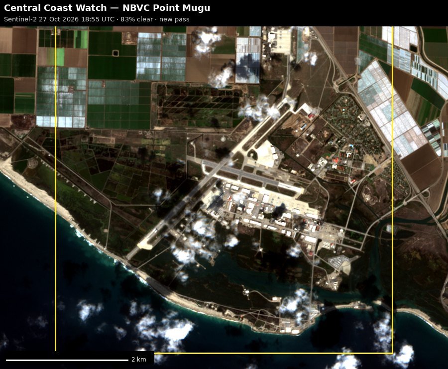
| NBVC Point Mugu | 6055 H60 (C6055) 01:24, 163310 C130 (SCORE60) 16:00, ae6832 (0 YP 00000000) 16:14, 06-1467 C30J (OCEAN12) 17:38, 02-1464 C30J (OCEAN11 OCEAN21) 19:22, 169443 V22 (RUDY37) 22:33; 6 civil |
| NBVC Port Hueneme | 6055 H60 (C6055) 01:27, 02-1464 C30J (OCEAN11 OCEAN21) 22:55 |
| San Nicolas Island (Navy range) | 167840 H60 (BT11 BT610) 00:10, 166764 C30J (RANGR75) 00:35, 02-1464 C30J (OCEAN11 OCEAN21) 20:07 |
Heat
0 detections in the watch box (FIRMS area API (agent Gazda)); 0 inside a site box. Launches from Vandenberg are short events; heat from a launch is caught only if a satellite passes within minutes.
Imagery
| Site | Newest clear Sentinel-2 pass (≤12 days) | |
|---|---|---|
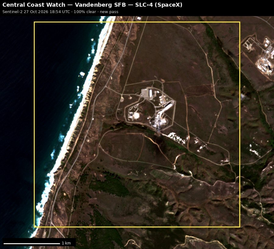
| Vandenberg SFB — SLC-4 (SpaceX) | 2026-10-27 18:54 UTC, 100% clear | no new pass |
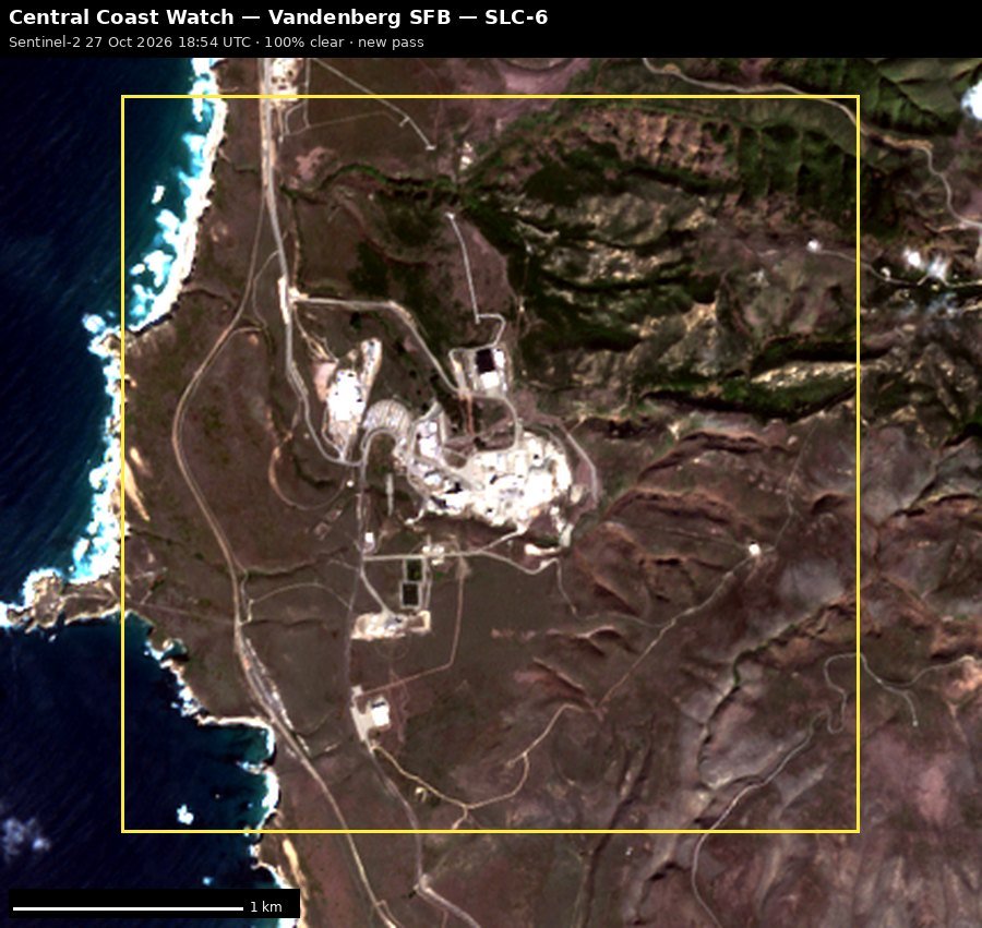
| Vandenberg SFB — SLC-6 | 2026-10-27 18:54 UTC, 99% clear | no new pass |
| Vandenberg SFB — north base test silos | 2026-10-27 18:54 UTC, 100% clear | no new pass |
| NBVC Point Mugu | 2026-10-27 18:55 UTC, 78% clear | no new pass |
| San Nicolas Island (Navy range) | 2026-10-24 18:45 UTC, 100% clear | no new pass |
RWI-W-CENTRALCOAST-2026-10-28flights 2026-10-27
- Unidentified aircraft a04eee (civil) within 25 km of San Nicolas Island 15:13–22:32 UTC.
- N189PA (SF34, civil) within 25 km of San Nicolas Island 14:26–23:37 UTC.
23 US military · 14 other low · 1 state/VIP · 0 heat (0 on sites)
 NBVC Point Mugu
 San Nicolas Island (Navy range)
 Vandenberg SFB — north base test silos
 Vandenberg SFB — SLC-4 (SpaceX)
 Vandenberg SFB — SLC-6
Full report
Vandenberg, Point Mugu and the Navy's offshore range. Daily open-source look; flights for 2026-10-27 (UTC), heat for 2026-10-27–2026-10-28, newest satellite passes. LLM-generated and automated.
Notable
- Unidentified aircraft a04eee (civil) within 25 km of San Nicolas Island 15:13–22:32 UTC.
- N189PA (SF34, civil) within 25 km of San Nicolas Island 14:26–23:37 UTC.
Flights
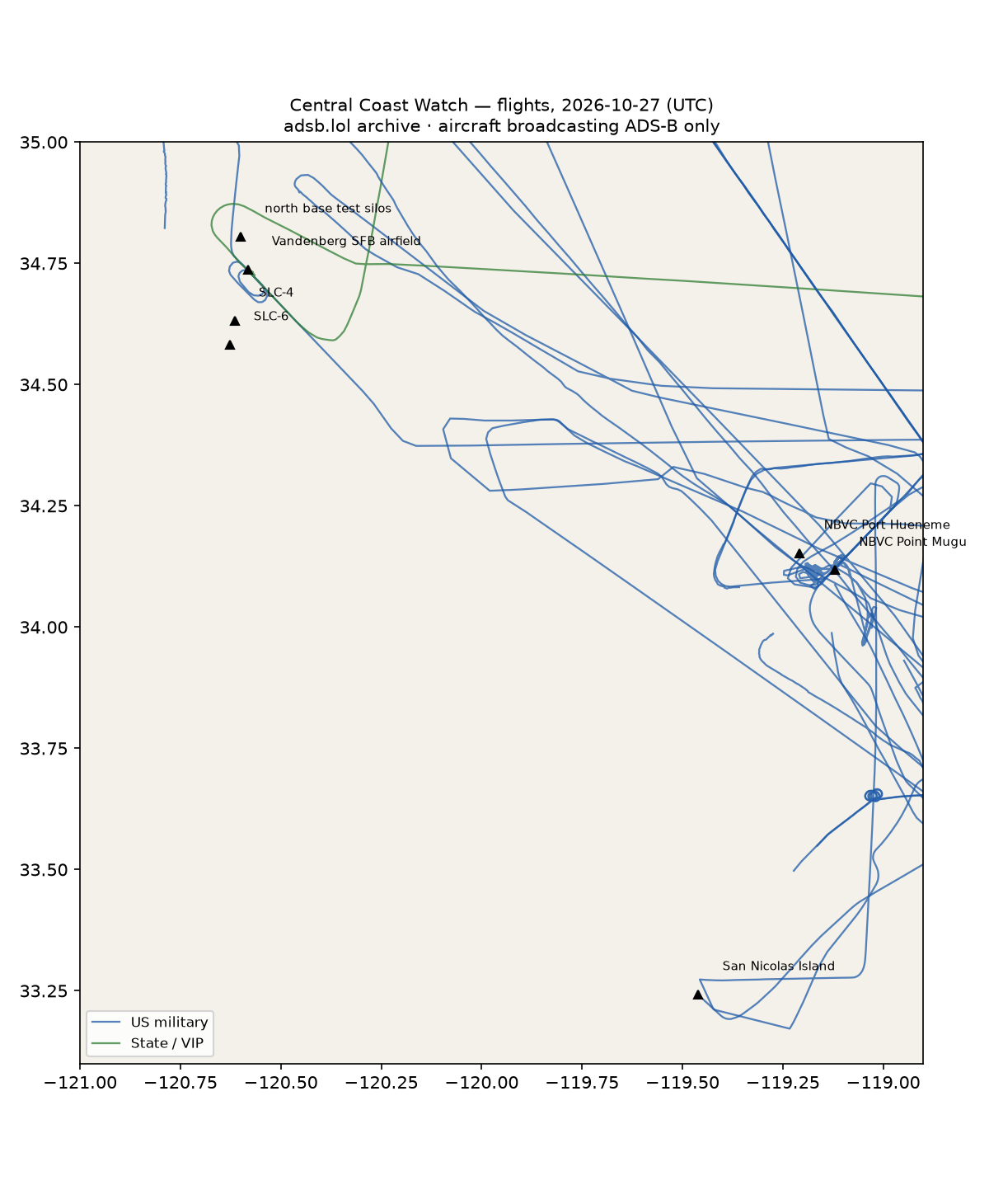
38 aircraft kept: 23 US military, 0 foreign military, 1 state/VIP, 14 other (on the ground at a site, or near a range).
Near San Nicolas Island (within 25 km; ordinary traffic below 18,000 ft)
| Aircraft | Type | Category | Callsigns | Seen (UTC) | Sites |
|---|---|---|---|---|---|
| 166764 | C30J | us-military | RANGR75 | 18:14–22:52 | San Nicolas Island |
| 163310 | C130 | us-military | SCORE60 | 18:24–21:23 | San Nicolas Island |
| a04eee | other | N27XJ | 15:13–22:32 | San Nicolas Island | |
| N189PA | SF34 | other | N189PA | 14:26–23:37 | San Nicolas Island |
| N374HA | A332 | other | ASA806 ASA809 | 00:24–23:29 | San Nicolas Island |
| N456AN | A21N | other | AAL2115 AAL266 AAL3184 | 04:37–04:40 | San Nicolas Island |
| N537DT | A21N | other | DAL459 DAL485 DAL571 DAL989 | 00:04–00:05 | San Nicolas Island |
US military
H60 ×4, C17 ×3, C30J ×3, BE20 ×2, ? ×2, C130 ×2, C560 ×1, V22 ×1, E2 ×1, B350 ×1, B762 ×1, C5M ×1, P3 ×1.
- ae6819 00000000 @@@@@@@@ at NBVC Point Mugu 00:15 UTC
- 01-1462 C30J OCEAN11 at NBVC Point Mugu 18:08 UTC
- 76-0161 BE20 COBRA18 WAYLN67 at NBVC Point Mugu 21:50 UTC
- 21-46095 B762 ORCA20 at Vandenberg SFB airfield 21:25 UTC
- 166764 C30J RANGR75 at San Nicolas Island 22:52 UTC
- 6055 H60 C6055 at NBVC Point Mugu 01:17, NBVC Port Hueneme 01:26 UTC
- 167822 H60 FFAB123 at NBVC Point Mugu 17:45, NBVC Port Hueneme 17:47 UTC
- 163310 C130 SCORE60 at NBVC Point Mugu 21:22 UTC
Foreign military
None broadcasting.
State and VIP
- UR-82027 A124 ANTONOV An-124 Ruslan ADB710F ADB7110 16:22–23:18 UTC — at Vandenberg SFB airfield
Landings and low passes by site
| Site | Military / government aircraft on the ground or ≤1,500 ft within 4 km; civil count |
|---|---|
| Vandenberg SFB — SLC-4 (SpaceX) | — |
| Vandenberg SFB — SLC-6 | — |
| Vandenberg SFB — north base test silos | — |
| Vandenberg SFB airfield | UR-82027 A124 (ADB710F ADB7110) 17:48, 21-46095 B762 (ORCA20) 21:25 |
| NBVC Point Mugu | ae6819 (00000000 @@@@@@@@) 00:15, 6055 H60 (C6055) 01:17, 167822 H60 (FFAB123) 17:45, 01-1462 C30J (OCEAN11) 18:08, 163310 C130 (SCORE60) 21:22, 76-0161 BE20 (COBRA18 WAYLN67) 21:50; 4 civil |
| NBVC Port Hueneme | 6055 H60 (C6055) 01:26, 167822 H60 (FFAB123) 17:47 |
| San Nicolas Island (Navy range) | 166764 C30J (RANGR75) 22:52; 1 civil |
Heat
0 detections in the watch box (FIRMS area API (agent Gazda)); 0 inside a site box. Launches from Vandenberg are short events; heat from a launch is caught only if a satellite passes within minutes.
Imagery
| Site | Newest clear Sentinel-2 pass (≤12 days) | |
|---|---|---|
| Vandenberg SFB — SLC-4 (SpaceX) | 2026-10-27 18:54 UTC, 100% clear | no new pass |
| Vandenberg SFB — SLC-6 | 2026-10-27 18:54 UTC, 100% clear | no new pass |
| Vandenberg SFB — north base test silos | 2026-10-27 18:54 UTC, 100% clear | no new pass |
| NBVC Point Mugu | 2026-10-27 18:55 UTC, 83% clear | no new pass |
| San Nicolas Island (Navy range) | 2026-10-24 18:45 UTC, 100% clear | no new pass |
RWI-W-CENTRALCOAST-2026-10-27flights 2026-10-26
- N118PA (SF34, other) within 25 km of San Nicolas Island 14:15–22:21 UTC.
- N143N (B350, other) within 25 km of San Nicolas Island 00:35–23:06 UTC.
- N189PA (SF34, other) within 25 km of San Nicolas Island 15:45–16:33 UTC.
- N130RL (BE20, other) within 25 km of San Nicolas Island 16:28–16:40 UTC.
- VH-OQB (A388, other) within 25 km of San Nicolas Island 05:18–05:19 UTC.
- N502DN (A359, other) within 25 km of San Nicolas Island 12:22–12:23 UTC.
- N801MR (DH8B, other) within 25 km of San Nicolas Island 15:19–15:24 UTC.
- N528DN (A359, other) within 25 km of San Nicolas Island 12:30–12:32 UTC.
- N526DE (A21N, other) within 25 km of San Nicolas Island 12:18–12:19 UTC.
16 US military · 20 other low · 1 heat (0 on sites)
Full report
Vandenberg, Point Mugu and the Navy's offshore range. Daily open-source look; flights for 2026-10-26 (UTC), heat for 2026-10-26–2026-10-27, newest satellite passes. LLM-generated and automated.
Notable
- N118PA (SF34, other) within 25 km of San Nicolas Island 14:15–22:21 UTC.
- N143N (B350, other) within 25 km of San Nicolas Island 00:35–23:06 UTC.
- N189PA (SF34, other) within 25 km of San Nicolas Island 15:45–16:33 UTC.
- N130RL (BE20, other) within 25 km of San Nicolas Island 16:28–16:40 UTC.
- VH-OQB (A388, other) within 25 km of San Nicolas Island 05:18–05:19 UTC.
- N502DN (A359, other) within 25 km of San Nicolas Island 12:22–12:23 UTC.
- N801MR (DH8B, other) within 25 km of San Nicolas Island 15:19–15:24 UTC.
- N528DN (A359, other) within 25 km of San Nicolas Island 12:30–12:32 UTC.
- N526DE (A21N, other) within 25 km of San Nicolas Island 12:18–12:19 UTC.
Flights
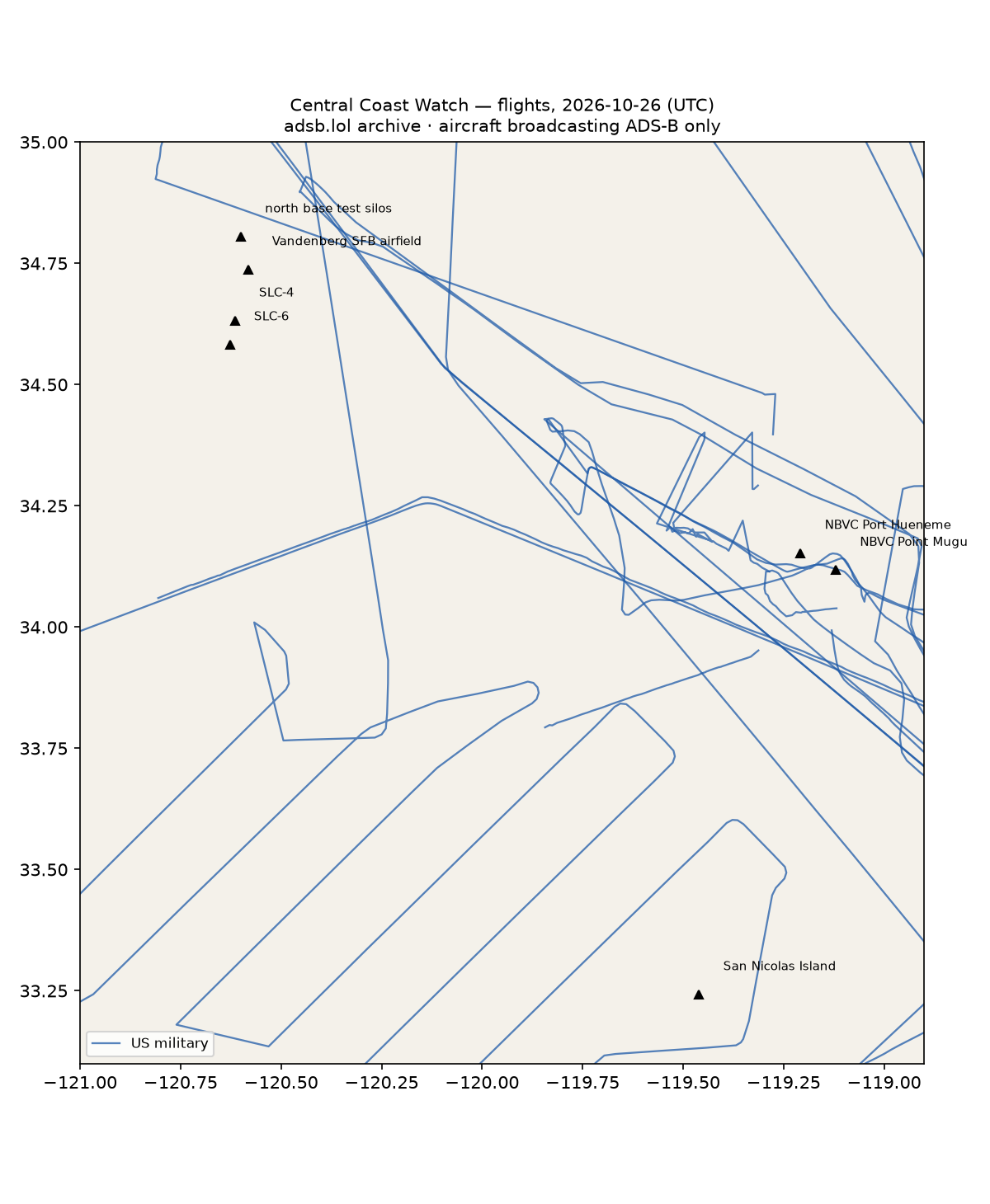
36 aircraft kept: 16 US military, 0 foreign military, 0 state/VIP, 20 other (on the ground at a site, or near a range).
Near San Nicolas Island (within 25 km; ordinary traffic below 18,000 ft)
| Aircraft | Type | Category | Callsigns | Seen (UTC) | Sites |
|---|---|---|---|---|---|
| N118PA | SF34 | other | N118PA | 14:15–22:21 | San Nicolas Island |
| N143N | B350 | other | TROY307 | 00:35–23:06 | San Nicolas Island |
| N189PA | SF34 | other | N189PA | 15:45–16:33 | San Nicolas Island |
| 2003 | C30J | us-military | 2003 C2003 | 02:47–11:01 | San Nicolas Island |
| N130RL | BE20 | other | N130RL | 16:28–16:40 | San Nicolas Island |
| VH-OQB | A388 | other | QFA12 VHOQB | 05:18–05:19 | San Nicolas Island |
| N502DN | A359 | other | DAL64 DAL782 | 12:22–12:23 | San Nicolas Island |
| N801MR | DH8B | other | 15:19–15:24 | San Nicolas Island | |
| N528DN | A359 | other | DAL40 | 12:30–12:32 | San Nicolas Island |
| N526DE | A21N | other | DAL326 DAL443 DAL515 DAL658 | 12:18–12:19 | San Nicolas Island |
US military
C30J ×4, H60 ×2, P3 ×2, B350 ×1, V22 ×1, C5M ×1, BE20 ×1, C27J ×1, C130 ×1, C17 ×1, ? ×1.
- 166534 H60 HEX707 at NBVC Point Mugu 18:19, NBVC Port Hueneme 18:23 UTC
- 168095 H60 HEX33 at NBVC Point Mugu 18:25, NBVC Port Hueneme 18:28 UTC
Foreign military
None broadcasting.
Landings and low passes by site
| Site | Military / government aircraft on the ground or ≤1,500 ft within 4 km; civil count |
|---|---|
| Vandenberg SFB — SLC-4 (SpaceX) | — |
| Vandenberg SFB — SLC-6 | — |
| Vandenberg SFB — north base test silos | — |
| Vandenberg SFB airfield | — |
| NBVC Point Mugu | 166534 H60 (HEX707) 18:19, 168095 H60 (HEX33) 18:25; 2 civil |
| NBVC Port Hueneme | 166534 H60 (HEX707) 18:23, 168095 H60 (HEX33) 18:28 |
| San Nicolas Island (Navy range) | 2 civil |
Heat
1 detections in the watch box (FIRMS area API (agent Gazda)); 0 inside a site box. Launches from Vandenberg are short events; heat from a launch is caught only if a satellite passes within minutes.
| Date | UTC | Lat, lon | FRP | Satellite | Site / nearest |
|---|---|---|---|---|---|
| 2026-10-26 | 0937 | 34.400, -118.998 | 0.35 | N | NBVC Point Mugu (33.3 km) |
Imagery
| Site | Newest clear Sentinel-2 pass (≤12 days) | |
|---|---|---|
| Vandenberg SFB — SLC-4 (SpaceX) | 2026-10-27 18:54 UTC, 100% clear | no new pass |
| Vandenberg SFB — SLC-6 | 2026-10-27 18:54 UTC, 100% clear | no new pass |
| Vandenberg SFB — north base test silos | 2026-10-27 18:54 UTC, 100% clear | no new pass |
| NBVC Point Mugu | 2026-10-27 18:55 UTC, 83% clear | no new pass |
| San Nicolas Island (Navy range) | 2026-10-24 18:45 UTC, 100% clear | no new pass |